
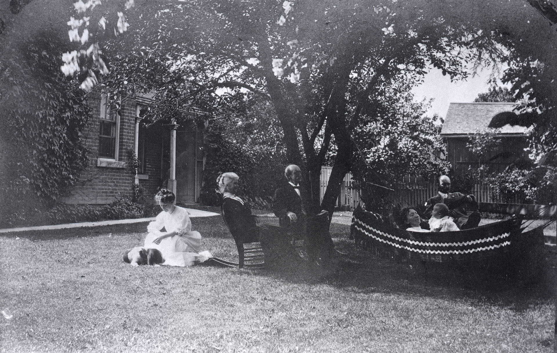
Thomas Heys house, Hogarth Ave., n.w. corner Bowden St. 1900
History of Riverdale - Short Version
The short version of the settlement of Riverdale can be summed up in this way: The fast flowing and powerful Don River linked prominent and connected British settlers, who used generous land grants along its shores in the late 18th Century to homestead in the valley, and through their extended families built and maintained their residences, while selling timber, hay, potash and various crops. In the 1800's, industries opened up South Riverdale/Leslieville, with the rise of paint, glue and oil factories, metal and processing plants, dairies, tanneries, and brickyards. The arrival of the Grand Trunk Railway in the 1850's led to the construction of workers houses in Leslieville, and from there, roads, bridges, infrastructure and domestication. In the 1920's and 30's, industry's continued spoilage had created a vast dump in and around the Don, leading to a perfect storm of squatters, criminals and the marginalized making camp in the bog. By the 1950's, The Don River's pollution was inescapable, and the area's residents and politicians would lead a long march to clean up and revitalize The Don. The post-war period also brought Greek, Chinese, Italian and African immigrants to Riverdale. creating pockets of vibrancy and difference. Today's million dollar homes and upscale shops betray Riverdale's often tempestuous and working class past.
Longer Version
The Riverdale that unfolds before your eyes in 2016 is hardly the one that Elizabeth Gwillim, wife of John Simcoe, the first lieutenant governor of Upper Canada, encountered in 1793 when she first arrived. According to author Elizabeth Muir in Riverdale, East of The Don, Gwillim thought The Don Valley was some sort of Eden. She sketched watercolours of people and places along the Don River, and took note of butterflies, birds, and wild flowers. There were rushes, ducks and black birds in the bog. At night, she would often watch The Indigenous Anishnaabe of the area spear salmon along The Don's banks, while mink, fox, deer, bear and wolves moved along the shores.


This was early days of Toronto (York), and before the successive waves of "beauty and plenty, then despoliation and now regeneration and beauty again," according to Muir, that has represented the history of The Don over the centuries.
At the turn of the 19th Century, it wasn't called The Don River by the Indigenous Anishnaabe. It was called Wonsconteonach, or "the river coming down from the back burnt country" (presumably a reference to a fire at some point). However, John Graves Simcoe wasn't interested in The French or Native roots of the area. He was determined to build a British colony, and named the river on the east side "The Don" after his favourite stream in Yorkshire, England. By 1797, there were thirty-five men and 24 women living in The Don Valley and marsh. There were also indigenous people camping east of the Don as late as 1831. The rural nature of The Danforth partly remained unchanged for decades because the Don Valley separated the area from the City.
In the 1790's, John Scadding, John Graves Simcoe's assistant, was given 253 acres by Graves, which ran from the waterfront to Danforth Avenue between the Don River and today's Broadview Avenue. It was at that time a pastoral homestead of sorts: "wheat, rye, barley, oats and maize were seen; and orchards containing a great variety of the finest kinds of apple and other fruits.... Asparagus beds and celery trenches were laid out; hemp was grown, and melons of all kinds.... In the flower garden bloomed most of the ordinary English flowers, especially roses of several species."
The theory at the time was that Graves gave Scadding the land to keep it out of "predatory" hands, and so Scadding sold lots to his trusted friends. He also built his famous log cabin on his property east of the Don River (where The DVP and Queen is now) in 1794 to fulfill his settlement duties to the Crown, and after it burned down, William Smith built another one on Scadding's behalf.
Eventually Scadding returned to England after Simcoe, and left his lands in Upper Canada to George Playter, his neighbour. After Simcoe died, his loyal servant Scadding returned to Riverdale and sold his land south of Queen to William Smith. Over the next hundred years Smith and his family would contribute significantly to the development of the town of York and the Don Mount/Riverdale neighbourhood.


Meanwhile George Playter, who had arrived in York in 1794, became an equally significant family in Riverdale's history. George and his sons were granted almost 2000 acres of land, such was the value of being related to John Graves Simcoe. The Playters owned land east and west of The Don, and were highly regarded in the community, as school commissioners, town clerks, and other roles in municipal affairs in the 1800's. They were market gardeners, dairymen and farmers, and owned a brickyard on what is now Broadview and Danforth. They were also heavily involved in the social life of the area.
However, life in the lower Don Valley in the 1800's wasn't without its hazards. Disease-laden mosquitos plagued early settlers and soldiers alike, and floods came in great waves, again and again, wiping out fences and crops, and reducing bridges to nothing. Every manner of human and natural creation went rushing down the powerful Don. In summer, there were droughts to deal with.
There were also virtually no roads at the time, and after Simcoe died, his successor, Honourable Peter Russell made building roads a priority. In 1799, an American salt purveyor named Asa Danforth came to Canada offering to build a road from York east to The Bay of Quinte. Plagued by financial problems, Danforth never completed the 100 mile road, but in 1800 he completed the section of the road that now bears his name (Danforth Rd). Even though Danforth Avenue is also named for him, he had nothing to do with its construction. His namesake remains, nonetheless.
Various attempts at bridges over The Don were made, starting with the first bridge in 1791, built by the Playter family. It was hardly strong enough and mostly impassable, and so in 1794, William Smith constructed "Scadding's Bridge" which crossed the Don River where King and Queen streets converged on the west bank and continued eastwards to Kingston Road. That was swept away by a flood, however, and after a new bridge was deliberately burned by The British during The War of 1812, and after various failed attempts at bridges, there was between 1830 and the 1850's historical records of at least three different bridges constructed over The Don. By 1878, a great flood washed away all the bridges across the Don, except a steel railway bridge near the lake. The theme of bridges–and their flooding–was a recurring one in Riverdale's history.
In the 1850's there was the creation of The Grand Trunk Railway, and Riverdale's transition from outpost to hive of human and industrial activity began. In 1896, the railway opened its Queen East station (at Degrassi) to serve Toronto's growing east end. With the railway came all manner of industry and jobs, and so began the construction of working class homes in South Riverdale (Riverside). It also gave local industries a chance to ship their products to other markets. North of Queen Street much of Riverdale remained largely undeveloped until 1884 when it was annexed by the City of Toronto.
In 1856 the City of Toronto purchased 120 acres of John Scadding's farm in order to construct a jail and an industrial farm on the site. The Don Jail, built on the east side of the river, opened in 1864. At the time it was considered a "palace for prisoners" in direct contrast to the manner in which prisoners were treated previously. Of course, by our standards, the way prisoners were treated in the new jail was also appalling, but it was considered a leap forward at the time.


Riverdale Park opened on the same site in 1880, and ten years later the jail property was separated out from the park lands. Leslieville and Riverside joined together and become "Riverdale" in 1884, bringing municipal services to the neighbourhood and providing new impetus for development.

Riverdale Park, 1910
Meanwhile, John Scadding had three children in England, and with his wife, the family followed John to York in 1821 where John built a larger house with a barn and stables in The Don Valley, near the Don Jail. Scadding grew hemp, rye, barley, corn, fruit and flowers and kept sheep and cattle. However, In 1824, he was killed by a falling tree, and his widow and children were left to look after the farm. In 1830, John Player's daughter Amelia married John Scadding Jr. and lived on The Scadding farm.
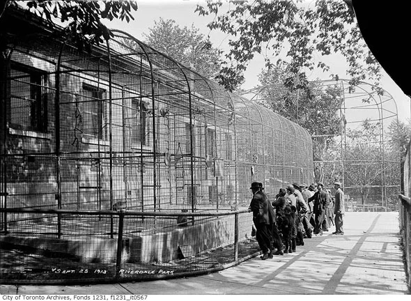
The Riverdale Zoo, Toronto's first, opened within Cabbagetown (west of the Don) in 1894 after several years of lobbying by Toronto alderman Daniel Lamb. The zoo functioned all the way until 1974, when The Toronto Zoo opened, and Riverdale's animals were transferred there. After that, Riverdale Farm opened in the old zoo spot, and was used to teach city children about rural life and food production at the turn of the 20th century.


The period from 1850-1920's in both Leslieville and Riverdale saw the rise of gardening and brickworks, including George Leslie's Nurseries. In 1845, Leslie moved east across the Don, leasing and then buying swampland so that by 1849, he owned 200 acres from Queen Street to the lake, and from roughly Pape Avenue to Leslie Street. His nursery was considered the largest in The British Empire. By 1876, there were 26 market gardeners using the Leslie Post Office, reflecting the prominence of gardening in Riverdale.
Farming, dairying, market gardening and selling flowers all came from the land. Riverdale soil was also ideal for making bricks. Astoundingly, at one time, over half of Leslieville's land surface were brickyards. From the 1850's to the 1870's there were at least nine brickyards in the area. A significant boost to the industry came in the 1850's when the combination of the rise of fire ordinances and a dearth of wood for house-building resulted in a spike in houses made of brick.

Construction of The Bloor Street Viaduct, 1919
After 1900, Riverdale housed all manner of industry, including printing, metals, food, and soap making. However, the rise of industry on the banks of The Don River also had rather devastating effects on the landscape, as blood from abattoirs and waste from factories poured into the river. By the end of the 19th century, the Lower Don had become filled with the waste from breweries, tanneries, soap factories, and oil refineries. So began almost 80 years of using the waterways of The Don as a dumping ground for industry.
As Elizabeth Muir points out, The Don River and The Don Valley had provided many of the basics of necessities in early settlement: food from the river and forest, lumber from trees, water for mills and farmland, clay for bricks. "Soon, hoover, the river became a sinkhole for wastes from sewers and industries, a dumping ground for the public and the city, and an isolated area for the marginalized." Squatters, gangsters and criminals found refuge in the lower valley. It was a place for institutionalized "undesirables"–the poor, homeless, mentally ill and quarantined.
The 20th Century brought better bridge building, and so in 1911, the present Queen Street bridge over the Don was constructed out of solid steel. Then the Prince Edward Viaduct was completed in 1919 linking all the "sleepy" little neighbourhoods along the Danforth Avenue with Bloor Street, close to the heart of the City. Buildings and shops sprung up along the Danforth throughout the 1920s as a result, many of which are still there today.


For her book Riverdale, East of The Don, writer Elizabeth Muir collects recollections of Riverdale at the turn of the last century, and while they are filled with struggles of the day, the memories are also etched with ecstasy and sensory delight, particularly around being a child at the time. Elsie Hallam Curtis, who lived on Arundel at the time, called the area from Broadview to Pape, "The Big Field". While it was often brutally cold, she and her friends would often skate the whole expanse of it, mindful of the powerful winds that would inevitably sweep across it. On weekends, they would skate at Danforth and Ellerbeck, toboggan at Withrow and Riverdale Parks, or sing songs with cocoa after church on Sunday. Meanwhile the artist John Richmond remembered all-day hockey games on The Don River on Saturdays.
As now, it was great to be a kid in Riverdale 100 years ago: There were the street games: "duck on the rock, crack the whip, horseshoes, hide-and-seek, kick the can, and catch and tag." Then there was the watch for the neighbourhood ice man, wherein the kids would pick up stray pieces, and suck on them like popsicles. They would stand under the railway bridge at Queen and DeGrassi when the steam engine passed by, and become enveloped in steam and smoke. They would pick strawberries at the Playter farm, and eat corn at a roast in The Valley. Many kids were barefoot from May 24 until September, joyfully squeezing mud in between their toes, and being filled with the nomadic delight of being wide-ranging kids in the reverie of nature.
As Muir points out, there were prizes for every conceivable hobby and activity, such as ping pong, horseshoe pitching, pony shows, public speaking, tennis, and so on. Store owners in the area gave out medals and prizes. There were 25 cent dances at The Y, bicycle races for boys, concerts and amusements in The Valley, and all manner of activities in the Riverdale of the 20's and 30's. Such was the idyllic nature of life for children in Riverdale prior to and through the wars.
In the late 50's construction of the Don Valley Parkway began, cutting through the centre of The Don Valley. The river's curves were smoothed out, banks altered, and more oil-laced run-off was added to the watershed. In return for taking land from The Valley, the city created soccer and football fields, a toboggan slope, a swimming pool, ice rink and tennis courts. The unintended side effect of construction was that it cleaned up the valley in significant ways.
By 1950, almost all of Riverdale was covered by "The Riverdale Plume", or severe air pollution. As the population grew, as Muir points out, so did river pollution. There were herbicides, pesticides, road salt and dog poop from paved surfaces. The Don Valley Conservation Report described the Don as a open sewer and its water the most polluted in the province. In 1958, when Princess Margaret visited The Don Valley as part of her Canadian tour, the city scattered lime chloride along the banks of The Don to mask its stench. It was clear to the area's residents that the politicians weren't interested in making real change to the Don's state, and so began a citizen's march to clean up the area. By the 1990's, most of the polluted land in the lower Don was transferred to the city for cleaning, and in 2001 The Toronto Waterfront Revitalization Corp. was created to begin a 25 year project to revitalize the Don. Today there are ambitious plans afoot.
Culturally, by 1961, Riverdale's British roots had begun to change. In 1951, 81 percent of the population of the Danforth and North Riverdale still claimed English, Scottish, or Irish as their ancestry, as did 75 percent in South Riverdale. By 1961, those figures had dropped dramatically, a result of the many families from other European countries coming to Canada for a better life. Italians made up a good portion of that immigration along Danforth East, and of course Greeks: Most Greek immigration to Canada took place from 1945-1971, and included skilled and unskilled workers. Many settled in Riverdale, mostly in North Riverdale.
By 1993, 400 area businesses along the Danforth petitioned the city to name the blocks on the Danforth east of Hampton "Greektown." The Taste of The Danforth has since become Toronto's ongoing yearly love affair with Greek food and culture, despite the fact that the neighbourhood is no longer predominantly Greek. Between 2001 and 2006, the small Greek population remaining dropped 22 percent, and the area is now as much defined by class as ethnicity or religious affiliation, due to skyrocketing house prices.
Meanwhile, at Broadview and Gerrard in 1970's, the old working class neighbourhood became Chinatown East. Real estate broker Edward Hou imagined it as a new haven for the Chinese who had been pushed out of the city's main Chinatown in order to built the new City Hall. By 1973, 4000 Chinese had moved in to Riverdale, many direct from Hong Kong. A decade later, it was The Vietnamese who streamed in. However, by 1996, the Chinese population in the area had peaked, at 37%, and by 2006 had dropped to 32%, as the flight to the suburbs began. Still Chinatown East is vibrant and pulsing with markets and shops, a microcosm of the diversity of the larger city.
Today, the makeup of Riverdale is happily a polyglot of colours, history and heritage, and the neighbourhood is better for it.
The text above is a mixture of historical sources, but is largely adapted from Elizabeth Muir's fabulous book Riverdale East of The Don. Click on the photo below to purchase–the digital version is a mere $10!

